


Trackbook GPS

คำอธิบายของTrackbook GPS
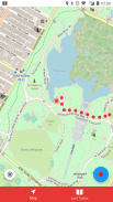
Trackbook is a bare bones app for recording your movements. Trackbook is great for hiking, vacation or workout. Once started it traces your movements on a map. The map data is provided by OpenStreetMap (OSM).
Trackbook is free software. You can find the code on GitHub (https://github.com/y20k/trackbook). GitHub is also a good place to file bugs or even to contribute, if you are interested. Trackbook is published under the MIT open source license. Trackbook uses osmdroid to display the map, which is also free software published under the Apache License.
HOW TO USE TRACKBOOK
+ Start recording movements
Press the big blue button to start recording your movements. Trackbook will continuously drop markers onto the map.
+ Stop recording movements
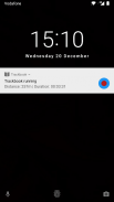
To stop your recording press the big blue button again or use the stop button in the Trackbook's notification. You can look at the recorded movements on the map afterwards.
+ Save last recording
Stop the recording and then tap again on the big blue button. It will offer an option to "Save and Clear". Trackbook stores saved recordings as plaintext JSON files in the directory /Android/data/org.y20k.trackbook/files/tracks.
+ Clear main map
Stop the recording and then tap again on the big blue button. Chose the option "Clear", if you just want to clear the map without saving your recording.
+ Statistics and Last Tracks
Peek into Trackbook's notification to see the distance and duration of your current recording. Switch to the "Last Tracks" view to review your last recordings. Trackbook stores up to 25 recent tracks. Pull up the statistics to see distance and duration of that recording, as well as the steps taken.
+ GPX Export
Saved recordings can be exported as GPX (GPS Exchange Format) from the "Last Tracks" view. Just tap the export icon next to the track selection menu.
+ How does Trackbook measure distance?
Trackbook calculates the distance between markers and adds them up.
WHICH PERMISSIONS DOES TRACKBOOK NEED?
+ Permission "INTERNET"
Trackbook needs to download map data from OpenStreetMap servers and therefore needs access to the internet.
+ Permission "ACCESS_NETWORK_STATE" and "ACCESS_WIFI_STATE"
Trackbook uses osmdroid to draw its maps. osmdroid needs to know the current state of your device’s connectivity.
+ Permission "ACCESS_COARSE_LOCATION" and "ACCESS_FINE_LOCATION"
Trackbook needs accurate GPS location data to be able to record your movements. If the GPS data is not available or not accurate enough Trackbook uses location data from cell tower and WiFi triangulation.
+ Permission "WRITE_EXTERNAL_STORAGE"
Trackbook uses osmdroid, which caches map tiles on Android's external storage. You can find the map cache in the "osmdroid" folder on the top level of the user-facing file system.
Trackbook เป็น app กระดูกเปลือยสำหรับการบันทึกการเคลื่อนไหวของคุณ Trackbook เป็นที่ดีสำหรับการเดินป่า, วันหยุดหรือการออกกำลังกาย เมื่อเริ่มต้นมันมีร่องรอยการเคลื่อนไหวของคุณบนแผนที่ ข้อมูลแผนที่ที่มีให้โดย OpenStreetMap (OSM)
Trackbook เป็นซอฟต์แวร์เสรี คุณสามารถค้นหารหัสบน GitHub (https://github.com/y20k/trackbook) GitHub ยังเป็นสถานที่ที่ดีที่จะยื่นข้อบกพร่องหรือแม้กระทั่งการมีส่วนร่วมถ้าคุณมีความสนใจ Trackbook มีการเผยแพร่ภายใต้ใบอนุญาต MIT โอเพนซอร์ส Trackbook ใช้ osmdroid เพื่อแสดงแผนที่ซึ่งยังเป็นซอฟต์แวร์เสรีเผยแพร่ภายใต้สัญญาอนุญาต Apache
HOW TO USE TRACKBOOK
+ เริ่มเคลื่อนไหวบันทึก
กดปุ่มสีฟ้าขนาดใหญ่ที่จะเริ่มต้นการบันทึกการเคลื่อนไหวของคุณ Trackbook อย่างต่อเนื่องจะลดลงเครื่องหมายลงบนแผนที่
+ การเคลื่อนไหวหยุดการบันทึก
หากต้องการหยุดการบันทึกของคุณกดปุ่มสีฟ้าขนาดใหญ่อีกครั้งหรือใช้ปุ่มหยุดในการแจ้งเตือนของ Trackbook คุณสามารถดูการเคลื่อนไหวที่บันทึกไว้บนแผนที่นั้น
+ บันทึกบันทึกล่าสุด
หยุดการบันทึกแล้วแตะอีกครั้งบนปุ่มสีฟ้าขนาดใหญ่ มันจะมีตัวเลือกในการ "บันทึกและล้าง" ร้านค้า Trackbook บันทึกบันทึกเป็นไฟล์ JSON ธรรมดาใน /Android/data/org.y20k.trackbook/files/tracks ไดเรกทอรี
+ แผนที่หลักที่ชัดเจน
หยุดการบันทึกแล้วแตะอีกครั้งบนปุ่มสีฟ้าขนาดใหญ่ เลือกตัวเลือก "ล้าง" ถ้าคุณเพียงต้องการที่จะล้างแผนที่โดยไม่บันทึกการบันทึกของคุณ
+ สถิติและเพลงล่าสุด
แอบมองเข้าไปในการแจ้งเตือน Trackbook เพื่อดูระยะทางและระยะเวลาในการบันทึกของคุณในปัจจุบัน สลับไป "เพลงสุดท้าย" มุมมองในการตรวจสอบการบันทึกครั้งสุดท้ายของคุณ ร้านค้า Trackbook ถึง 25 แทร็คที่ผ่านมา ดึงสถิติเพื่อดูระยะทางและระยะเวลาของการบันทึกว่าเช่นเดียวกับขั้นตอนดำเนินการ
+ การส่งออก GPX
บันทึกบันทึกไว้สามารถส่งออกเป็น GPX (GPS รูปแบบ Exchange) จาก "เพลงสุดท้าย" มุมมอง เพียงแค่แตะที่ไอคอนการส่งออกต่อไปที่เมนูเลือกการติดตาม
+ วิธีการวัดระยะห่าง Trackbook?
Trackbook คำนวณระยะห่างระหว่างเครื่องหมายและเพิ่มพวกเขาขึ้น
สิทธิ์ไม TRACKBOOK ต้อง?
+ อนุญาต "อินเทอร์เน็ต"
Trackbook จำเป็นต้องดาวน์โหลดข้อมูลแผนที่จากเซิร์ฟเวอร์ OpenStreetMap และดังนั้นจึงต้องการการเข้าถึงอินเทอร์เน็ต
+ อนุญาต "ACCESS_NETWORK_STATE" และ "ACCESS_WIFI_STATE"
Trackbook ใช้ osmdroid การวาดแผนที่ของมัน osmdroid ต้องการทราบสถานะปัจจุบันของการเชื่อมต่ออุปกรณ์ของคุณ
+ อนุญาต "ACCESS_COARSE_LOCATION" และ "ACCESS_FINE_LOCATION"
Trackbook ต้องการข้อมูลตำแหน่ง GPS ที่ถูกต้องเพื่อให้สามารถบันทึกการเคลื่อนไหวของคุณ หากข้อมูล GPS ไม่สามารถใช้ได้หรือไม่ถูกต้องเพียงพอ Trackbook ใช้ข้อมูลสถานที่จากหอโทรศัพท์มือถือและ WiFi สามเหลี่ยม
+ อนุญาต "WRITE_EXTERNAL_STORAG E ที่"
Trackbook ใช้ osmdroid ซึ่งแคชกระเบื้องแผนที่ที่จัดเก็บข้อมูลภายนอกของ Android คุณสามารถค้นหาแคชแผนที่ในโฟลเดอร์ "osmdroid" ในระดับบนสุดของระบบไฟล์ของผู้ใช้หันหน้าไปทาง
Trackbook GPS--เวอร์ชั่น1.1.12
(10-11-2018)
Trackbook GPS - ข้อมูล APK
เวอร์ชั่น APK: 1.1.12แพ็คเกจ: org.y20k.trackbookเวอร์ชั่นล่าสุดของTrackbook GPS


 3.38
3.38

 4.34
4.34


แอปในประเภทเดียวกัน


